In a life threatening emergency dial Triple Zero (000)
Storm and Flood Assistance
Canberra is a city designed and built within a bush and grass landscape where residents are able to live, work and play among nature, hence the term, The Bush Capital.
This means bushfires are an inevitable fact of life in the ACT.
In this section of our website, we aim to provide you with a comprehensive range of information about bushfires and advice about what you and your family or household must do to reduce the impact when a fire or fires occur near your home, your place of work or recreation.
This could be within the city limits or out in the rural areas of the Territory.
These actions are required long before a fire starts, on a day of elevated fire danger and when a fire starts.
Bushfires have long been a part of the ACT landscape. Flammable vegetation, long hot summers and periodic drought have regularly combined to produce bushfires and varying size and intensity. Climate change will impact on all aspects of bushfire risk and will lead to longer and more severe bushfire seasons.
In the ACT the bushfire season commences on 1 October and runs through until 31 March, unless conditions warrant a variation in which case the ESA Commissioner may vary the season. Within the bushfire season there are restrictions on the use of fire for burning off, and penalties for a range of bushfire-related offences are increased.
All Canberrans should ensure they understand Fire Danger Rating (FDR) levels to help them make decisions when travelling in and around the ACT. The FDR is displayed on electronic signs on all major arterial roads across the ACT, as well as on the home page of the ESA website.
During the bushfire season, rural landowners and managers must obtain a free permit from the ACT Rural Fire Service before conducting hazard reduction burns. To apply for a permit contact 6207 8609, or send an email request to rfs@act.gov.au.
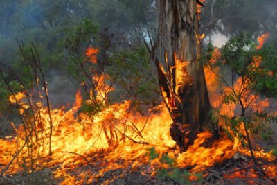
A bushfire is a fire that burns in grass, bush or woodland and can threaten life, property and the environment. Here in the ACT, which is also nicknamed the "bush capital", we have encouraged the "bush" to grow within our city so this means we will experience bushfire both in the farm lands, (or what we term the rural areas), as well as inside our suburbs. Where the suburbs or urban development meet the rural lands is of particular concern to fire services as it places a great number off our community at high risk from bushfire each year.
Anything that burns is fuel for a fire, in particular leaf litter (which is the accumulation of leaves, twigs, bark and rubbish on the ground), undergrowth (shrubs, grass, seedlings), trees and other vegetation. We also include structures (such as houses, stables, sheds etc.) as fuel and any other object that will burn when exposed to flames; such as gas bottles, piles of firewood, tyres, etc.
When we talk about fuels we often refer to their height. This is because fuels are found on the ground all the way up to the top of the trees, and where there are fuels fire can burn so fires can be quite small but can also reach up to 30 metres. An important term to understand is ladder fuels, which is any vegetation that grows between the ground fuel up to about 2 metres. This vegetation provides a path, or ladder, for a fire to travel up, taking the flames from the ground right up into the tree tops, essentially growing the fire from 1-2 metre flames right up to 30 metre flames.
Weather plays a major role in the severity of bushfires. The hotter and dryer the weather is, the more likely it is for a bushfire to start and spread quickly. Most bushfires start in the afternoon, when it is driest and hottest.
Wind speed can influence a bushfire by pushing the fire forward, the stronger the wind the faster the bushfire can spread. Wind can also dry out the air by reduce the moisture, this is called "low humidity". When there is low humidity the danger of dry lightning (lightning from a storm that brings little or no rain) starting a bushfire is very high.
Topography is the slope of the land and it plays a major factor in bushfire behaviour. Very simply, a bushfire will move up much faster up a slope and slow down as it goes down a slope. With all factors being equal, a bushfire will actually double the rate at which it spreads for each 10 degrees that a slope increases.
The Australian bush can, very generally, be described as shrubs, bushes and small trees from ankle or knee height right up to the tallest of trees. The term we use for bush here on the East coast of Australia is, "Sclerophyll forest", and it covers much of the coastal and mountainous areas in and around NSW and the ACT.
The most common species in these forests are eucalypt trees and as such, fire in a sclerophyll forest is what most Australians probably think of when they hear the words "bushfire". The leaves of eucalyptus contain flammable oils that burn extremely well in a fire. But it is also important to remember that fire is a natural part of the environment and not only are many of the species fire resistant, but some actually depend on fire to trigger new growth and to germinate seeds.
The ACT is surrounded by bush or forest, particularly in the Brindabella mountains to the west and north, where our greatest fire threat comes from. However, there are large tracks of what we call Lowland or open woodland that surround the rural and suburban areas of Canberra where both grassland and scattered shrubs and trees grow.
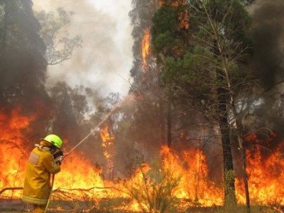
Bush or forest fires are quite different to grassfire because:
As a result, bush or forest fires can be difficult for fire fighters to control and they are the most destructive of any fire and usually consume all in its path.
As a general rule, flame height is between three (3) to five (5) times the height of the fuel that is burning. So, if one (1) metre grass is burning then the height of the flame could possibly be between 3 to 5 metres high, but if you had a 10 metre tall tree burning the height of the flames could be 30 metres or greater.
Another point of difference between grassfire and bush or forest fire is that trees and shrubs drop leaves, bark and twigs (fine fuels) down to the ground underneath them. Over time this fine fuel gets thicker and deeper. Fire needs fine fuel to start and burn well, so the more that accumulates underneath vegetation the hotter and more dangerous a fire can become. If a fire was to start or an ember was to land in this fine fuel it would burn very well and would help the fire to climb up the bark and branches of a tree into the tree tops or canopy.
When a fire gets up into the canopy it is very hot and dangerous and is called a crown fire. This type of fire was experienced in the Canberra 2003 bushfires and is beyond the direct control of our fire fighters.
Bush and forest fires also create larger and longer lasting embers than from a grassfire. These embers can travel over many kilometres before landing and starting another, new spot fire well ahead of the main fire front. Falling material from a crown fire can also start new surface fires below.
In a severe fire, the heavier fuels such as branches, logs and tree trunks can become involved in fire, particularly if they are already dead and dried out.
To prepare for bushfire, it is important to know your level of bushfire risk.
Even if your home is not located in the designated bushfire prone area, you may work, travel or spend time in bushfire prone areas.
Rural landholders or others who live, work or recreate in our rural areas need to be aware of the bush and fire threat in these areas and Prepare. Act. Survive.
Landholders in particular may have obligations in their lease to prevent fire occurring or spreading from their properties. To assist in this area the ACTRFS facilitates the Farm FireWise Program.
![]()
ACT Farm FireWise (FFW) is an exciting program that has been developed by the ACTRFS to support and assist the rural community in their prevention, preparedness, response and recovery actions and capabilities. This program was reviewed in August 2022 to align with the new Australian Fire Danger Rating System (AFDRS) coming into effect from 1st September 2022.
It is a tool that has been tailor-made to suit ACT rural landholders, their leasing arrangements as well as farming practices.
Central to the program is the identification of property access, asset protection zones, strategic fire advantage zones and asset protection priorities. Also provided through the process is key information of estimated fire behaviour for each property, dependant on the fire fuel, for each of the fire danger ratings. FFW plans allow the ACTRFS to prepare incident action plans to minimise the impact of fire on rural enterprises and assist in recovery efforts and assists with the protection of the urban community.
The FFW plan consists of a property map identifying fences, gates, fire trails, structures, asset protection and strategic fire advantage zones, water sources, access considerations (eg. gully erosion and water courses) and latest aerial imagery. It also consists of a Bushfire Operational Plan (BOP) which contains details of property contacts (including emergency contact), asset protection and strategic fire advantage zone works, access issues and details, asset protection priority, firefighting equipment and protection systems, hazardous materials and estimated fire behaviour under each fire danger rating. This assists ACTRFS and ESA appropriately respond to bushfires impacting on rural land and work with rural landholders to reduce the risk to themselves and the broader ACT community.
Rural landholders are also encouraged to develop and review their emergency survival plan, to ensure it is up to date and that they are familiar with it.
For more details on the FFW program please contact the Senior Rural Liaison Officer on (02) 6207 8609 or email rfs@act.gov.au.
The ACT is fondly referred by many as the "Bush Capital", and we pride ourselves in having generous swathes of open space between our suburbs and throughout our streets, bringing nature well into the heart of our city.
Black Mountain tower and its reserve on the outskirts of O'Conner, Turner, Cook and Aranda is a perfect example of that, with the Australian National University snuggled up beneath it. But bringing nature to our doorstep and work place can present risks, in this case the threat of bushfire travelling well into our suburban streets.
For those in our community that live, work or recreate beside, or close to open spaces, reserves and nature parks, you are classified as living on the city-rural interface. You need to take action each and every fire season to prepare you, your family and your home - PREPARE. ACT. SURVIVE
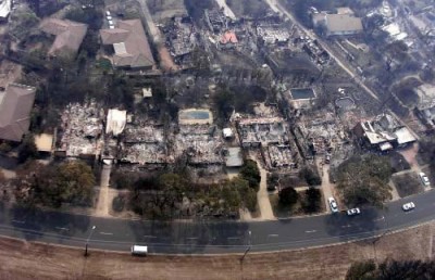
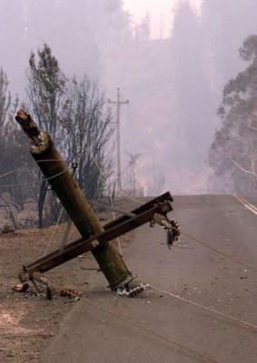
Even if you live several streets back from these interface areas you are not necessarily safe from bushfire. The Canberra 2003 bushfires demonstrated how powerful a bushfire can be and how it can reach well inside a suburb to destroy lives and homes.
It is not only those who live and work in areas of high bushfire risk that need to take action and stay alert during a bushfire season - everyone can be affected at some point. For example, bushfires create thick smoke that can turn day into night and drift over areas making driving very dangerous for everyone. In many cases roads will be blocked.
During and after a fire, roads become even more dangerous with powerlines and trees fallen down across streets and bridges damaged.
Be aware of wandering animals and look out for any distressed people who may not be alert to their surroundings. Also be aware that emergency vehicles and personnel are responding from one place to another and may be hard to see due to the smoke.
So stay off the roads as long as possible and DO NOT GO FOR A DRIVE TO SEE WHAT IS GOING ON as you will threaten yourself, your passengers and other people at the scene.
Then you too are at high risk from bushfire - PREPARE. ACT. SURVIVE.
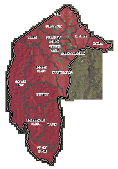
The BPA is a risk-based map that shows the area of the ACT that has been assessed as being at high risk to bushfires. Canberra's urban areas that are adjacent to forest and grassland are defined as BPA, as is the ACT's entire rural area. Currently, close to a quarter of all dwellings in the ACT are located in the area identified as BPA.
The BPA map provides the means by which people can assess their level of bushfire risk and supports the ESA's targeted community education and awareness campaigns for bushfires.
Areas of BPA may also be used to trigger assessment to determine the necessary construction standards for new buildings or significant renovations in order to meet the Australian Standard (AS) 3959 - Construction of buildings in bushfire prone areas.
The BPA map will continue to be reviewed and refined to reflect changes in land use and ownership and as improved vegetation mapping becomes available.
Canberra currently has the highest number of horse owners per capita of any city in Australia with over 1,000 horses currently kept on agistment centres (both public and private).
Many horse owners spend a lot of time with their horses, and in doing so are placing themselves in locations of high risk from bushfire.
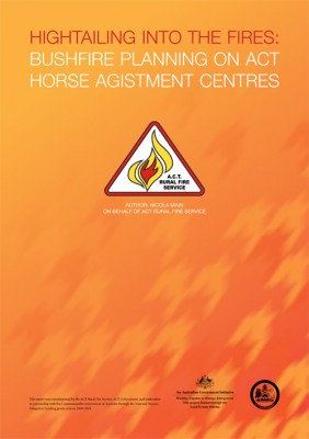
This, coupled with the tragic first hand experiences at horse agistment properties during the 2003 bushfires led the ACT RFS to commission a study into the bushfire operational planning of ACT horse agistment properties (Hightailing it into the fire – Bushfire planning on ACT horse agistment centres).
The study provided the ACT RFS with a better understanding of this industry and the needs of horses, horse owners and managers of agistment paddocks. The ESA has used the lessons from this report to provide more relevant and effective support and assistance to horse agistors /owners. This has included improving the Farm Firewise program to reflect the specific needs of horses and their owners. RFS members have also been trained to ensure they have a better understanding of how to work with horse agistment managers to protect people, properties and horses from bushfire.
People who agist their horses on fire prone land need to plan for their own safety in the event of bushfire.
Will Your Horse Stay or Go? – The ACT Equestrian Association Inc
Hightailing Into The Fires: 2011 Bushfire Planning on ACT Horse Agistment Centres [.PDF 1.5 MB]
You can stop bushfire arson occurring!
You can assist in keeping your community safe from deliberately lit bushfires. Remember, all deliberately lit bush and grass fires are a threat to your community (no matter how small they are). Bushfire arson is not tolerated in the ACT and is taken very seriously by police and the ESA.
Be alert and take notice of
When a fire starts
What to do with this information?
Your information could stop the next bushfire from being lit!
Face the facts
Bushfire arson in the national capital
Penalties
Persons convicted of lighting fires may face significant fines or even imprisonment for up to 25 years.