In a life threatening emergency dial Triple Zero (000)
Storm and Flood Assistance
The Adaminaby Complex fire was downgraded to WATCH AND ACT warning level after difficult weather conditions impacted the fire grounds yesterday.
ACT and NSW crews continue to monitor and extinguish hotspots on this fireground. Overnight rain in the area has also been advantageous to on ground firefighting efforts.
Mary's Hill fire has nil fire activity and is at ADVICE warning level. Light rain overnight is helping efforts to extinguish the fire.
While the Beard, Adaminaby Complex and Mary's Hill fires has our immediate attention, we remain vigilant and continuing to monitor and patrol the broader Brindabella area.

This is information is accurate as at 11am, Wednesday 22nd January 2020.
ACT ESA will continue to monitor fire activity in and around the ACT.
At the time of publication there are no major bush or grass fires in the ACT.
The fires to the West of the ACT have seen minimal activity overnight.
For the most up to date information on fires in NSW visit the NSW Rural Fire Service website.
Please note, figures are likely to increase and decrease as aerial intelligence captures new data.
The Mary’s Hill Fire has moved no closer to the ACT border overnight.
The fire remains 4.6 km west of the ACT border, and approximately 33.5 km from the urban interface.
The fire is currently 2,127 hectares in size.
Between 60-70mls of rain has fallen on the fireground.
These conditions have assisted firefighters to conduct direct firefighting on the ground.
Two NSW Remote Area Firefighting Teams (RAFT) and one ACT RAFT are working to extinguish hotspots today.
ACT’s helicopter Firebird 100 will continue to monitor and map the fire.
There is no active flame or smoke identified on the perimeter of the fireground.
The status of this fire is Being Controlled. This means Effective strategies are in operation or planned for the entire perimeter of the fire.
The fire is now 1.6 km south-west of the ACT border and 48 km from the suburban edge of Canberra.
This fire is currently 93,650 hectares in size.
ACT firefighters, alongside NSW continue to monitor fire activity in the area.
The status of this fire is Being Controlled. This means Effective strategies are in operation or planned for the entire perimeter of the fire.
The Dunn’s Road Fire is 20 km west of the ACT border and 46.7 km from the urban interface.
It is currently 333,277 hectares in size and is still burning within containment lines.
ESA will continue to monitor the activity of the fire.
The Dunns Road Fire has also received a significant amount of rain.
60-70mls has fallen on the ground fireground.
There is no active flame or smoke identified on the perimeter of the fireground.

Today, ACT Remote Area Firefighting Teams (RAFT) were transported and winched onto the Mary's Hill fire ground by Helitak 274 and 275 to undertake firefighting due to rugged terrain. Firebird 100 conducted a reconnaissance flight, identifying hot spots in the area. This data along with footage was used to task and brief crews working on the fire ground. ACT firefighters have also been driving the perimeter of Mary's Road to blackout and extinguish accessible hot spots. This work helped strengthen containment lines on all edges of the fire. The fire is currently being controlled. Tireless efforts of ACT fire crews today with favourable weather conditions have reduced fire activity. The fire remains 4.6 km west of the ACT border, and approximately 33.5 km from the urban interface. The fire is currently 2,125 hectares in size. Conditions on the Dunns Road and Adaminaby Complex Fire remain unchanged.
This information is current as of 15:00pm, Friday 17th January 2020.
ACT ESA will continue to monitor fire activity in and around the ACT.
At the time of publication there are no major bush or grass fires in the ACT.
The fires to the West of the ACT have seen minimal activity overnight.
For the most up to date information on fires in NSW visit the NSW Rural Fire Service website.
Please note, figures are likely to increase and decrease as aerial intelligence captures new data.
The Mary’s Hill Fire has moved no closer to the ACT border overnight.
The fire remains 4.6 km west of the ACT border, and approximately 33.5 km from the urban interface.
The fire is currently 2,100 hectares in size.
Between 5 – 10mls of rain fell on the fire ground overnight. This has assisted firefighters to conduct direct firefighting on the ground.
ACT’s helicopter, Firebird 100, is monitoring and mapping the fire, and undertaking lightning detection that may have occurred.
In addition, four helicopters are undertaking water-bombing activities on the fire edge.
ACT crews are assisting NSW to continue to strengthen containment lines and operate heavy plant such as dozers.
Planning is underway for significant additional ACT crews to be on the fireground from Saturday.
The status of this fire is Being Controlled. This means Effective strategies are in operation or planned for the entire perimeter of the fire.
The fire is now 1.8 km south-west of the ACT border and 48 km from the suburban edge of Canberra.
This fire is currently 93,650 hectares in size.
22mls of rain was recorded in the are over the fireground last night.
ACT firefighters, alongside NSW continue to monitor fire activity in the area.
The status of this fire is Being Controlled. This means Effective strategies are in operation or planned for the entire perimeter of the fire.
The Dunn’s Road Fire is 20 km west of the ACT border and 46.7 km from the urban interface.
It is currently 331,995 hectares in size and is still burning within containment lines.
ESA will continue to monitor the activity of the fire.

The Mary’s Hill Fire has moved no closer to the ACT border overnight.
The fire remains 4.6 km west of the ACT border, and approximately 33.5 km from the urban interface.
The fire is currently 2,100 hectares in size.
Between 5 – 10mls of rain fell on the fire ground overnight. This has assisted firefighters to conduct direct firefighting on the ground.
ACT’s helicopter, Firebird 100, is monitoring and mapping the fire, and undertaking lightning detection that may have occurred. In addition, three helicopters are undertaking water-bombing activities on the fire edge.
ACT crews are assisting NSW to continue to strengthen containment lines and operate heavy plant such as dozers.
Planning is underway for significant additional ACT crews to be on the fireground from Saturday.

This information is current as of 14:30pm, Thursday 16 January 2020.
ACT ESA will continue to monitor fire activity in and around the ACT.
At the time of publication there are no major bush or grass fires in the ACT.
For the most up to date information on fires in NSW visit the NSW Rural Fire Service website.
Please note, figures are likely to increase and decrease as aerial intelligence captures new data.
Mary’s Hill Fire is 4.6 km west of the ACT border, and approximately 33.5 km from the urban interface.
The fire is 1,874 hectares in size.
Prior to the arrival of the forecast rain, the wind associated with the predicted storm activity has impacted all fire grounds.
This has resulted in increased fire activity, which is being managed by NSW and ACT grounds crews.
ACT crews are assisting NSW to continue to strengthening containment lines and operate heavy plant such as Dozers.
Planning is underway for additional ACT crews to be on the fireground on Saturday.
ACT’s Firebird 100 is monitoring and mapping the fire and undertaking lightning detection that may have occurred following the storm activity.
The status of this fire is Being Controlled. This means Effective strategies are in operation or planned for the entire perimeter of the fire.
The fire is now 1.6 km south-west of the ACT border and 48 km from the suburban edge of Canberra.
This fire is currently 93,650 hectares in size.
ACT firefighters, alongside NSW continue to monitor fire activity in the area.
The status of this fire is Being Controlled. This means Effective strategies are in operation or planned for the entire perimeter of the fire.
The Dunn’s Road Fire is 20 km west of the ACT border and 46.7 km from the urban interface.
It is currently 331,981 hectares in size and is still burning within proposed containment lines.
ESA will continue to monitor the activity of the fire.
This information is current as of 19:20pm, Wednesday 15 January 2020.
ACT ESA will continue to monitor fire activity in and around the ACT.
At the time of publication there are no major bush or grass fires in the ACT.
For the most up to date information on fires in NSW visit the NSW Rural Fire Service website.
Please note, figures are likely to increase and decrease as aerial intelligence captures new data.
Mary’s Hill Fire is 4.8 km west of the ACT border, and approximately 33.5 km from the urban interface.
The fire is 1,546 hectares in size.
ESA has extended the deployment of ACT crews who are assisting NSW on the ground strengthening containment lines and heavy plant such as Dozers.
ACT aircraft continue to monitor and map the fire, whilst assisting NSW to conduct waterbombing operations.
The fire is now 1.8 km south-west of the ACT border and 48 km from the suburban edge of Canberra.
This fire is currently 93,650 hectares in size.
ACT firefighters continue to monitor fire activity in the area.
The Dunn’s Road Fire is 20 km west of the ACT border and 46.7 km from the urban interface.
It is currently 331,675 hectares in size and is still burning within proposed containment lines.
ESA will continue to monitor the activity of the fire.

Information update - Mary's Hill Fire in NSW
There continues to be significant fire activity at the Mary's Hill Fire in NSW.
This fire is 4.8 km west of the ACT border, and approximately 35.5 km from the urban interface and 32 km from the closest remote property.
The fire is 1546 hectares in size.
ESA will continue to support NSW on the fire ground with ground crews, appliances and heavy plant.
ACT aircraft will continue to monitor the fire ground and undertake water-bombing operations.
This information is current as of 10:30 Wednesday 15 January 2020.
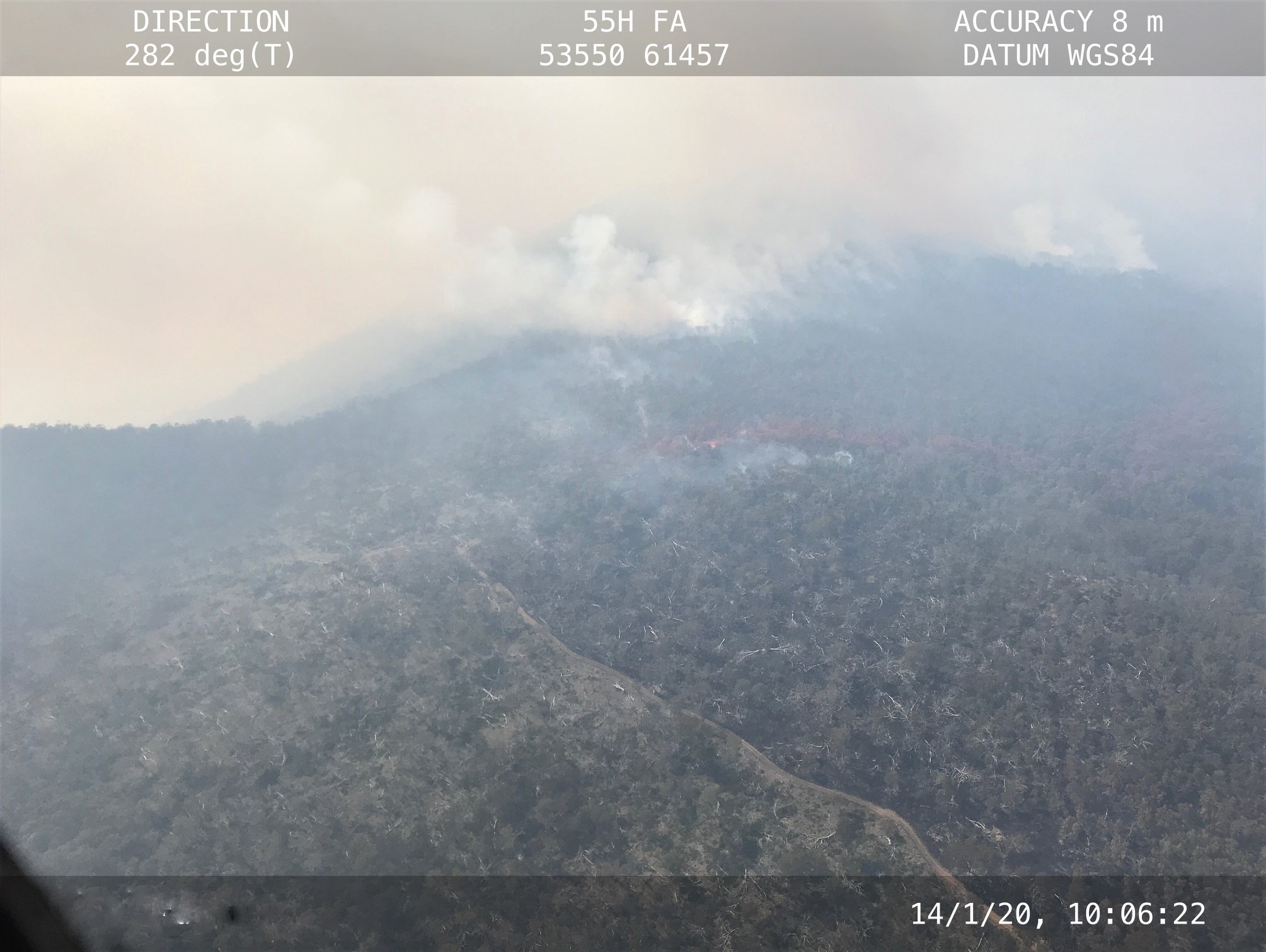
Information update - Mary's Hill Fire in NSW
Today's weather conditions resulted in significant fire activity at the Mary's Hill Fire in NSW.
This fire is 5.4 km west of the ACT border, and approximately 37 km from the urban interface and 32 km from the closest remote property.
The fire is 1124 hectares in size.
ESA will continue to support NSW to identify possible containment strategies.
Today the ACT strike team, two RAFT crews, two heavy tankers and heavy plant worked alongside NSW on the fire-ground.
ACT aircraft continue to monitor the fire ground and undertake water-bombing operations.
This information is current as of 19:30 Tuesday 14 January 2020.

This information is current as of 15:45pm, Tuesday 14 January 2020.
ACT ESA will continue to monitor fire activity in and around the ACT.
At the time of publication there are no major bush or grass fires in the ACT.
For the most up to date information on fires in NSW visit the NSW Rural Fire Service website.
Please note, figures are likely to increase and decrease as aerial intelligence captures new data.
This fire is 6 km west of the ACT border, and approximately 37 km from the urban interface and 32 km from the closest remote property.
The fire is 1124 hectares in size.
ACT support has been increased with two RAFT crews, two heavy tankers and heavy plant working on the fireground.
This is in addition to the ACT strike team working with NSW to strengthen containment lines.
ACT aircraft continue to monitor the fire ground and undertake water-bombing operations.
The fire is now 2.5 km south-west of the ACT border and 48km from the urban interface.
This fire is currently 88,889 hectares in size.
ACT crews continue to work with our NSW colleagues building containment lines and are closely monitoring this fire activity.
There has been little activity at the Dunns Road Fire today.
This fire is 18 km west of the ACT border and 49 km from the urban interface.
The fire is 338,914 hectares in size and has not breached the containment lines established closest to the ACT border.
ESA will continue to monitor the activity of the fire.
This information is current as of 17:45pm, Monday 13 January 2020.
ACT ESA will continue to monitor fire activity in and around the ACT.
At the time of publication there are no major bush or grass fires in the ACT.
For the most up to date information on fires in NSW visit the NSW Rural Fire Service website.
Please note, figures are likely to increase and decrease as aerial intelligence captures new data.
This fire is 7 km west of the ACT border, and approximately 39 km from the urban interface.
ESA mapping indicates that the fire has grown to 570 hectares in size and has only spread 600m towards the ACT.
The fire is burning within containment lines on the North, South and Western edges.
Favourable weather conditions have enabled ACT crews to assist NSW to strengthen containment lines.
Aircraft continue to monitor the fire ground and undertake water-bombing operations.
Aerial surveillance has identified an increase in fire activity at the Adaminaby Complex Fire.
The fire is now 2.5 km south-west of the ACT border and 48km from the urban interface.
This fire is currently 85,000 hectares in size.
ACT crews continue to work with our NSW colleagues building containment lines and are closely monitoring this fire activity.
This fire is 18 km west of the ACT border and 49 km from the urban interface.
The fire is 337,035 hectares in size and has not breached the containment lines established closest to the ACT border.
ESA will continue to monitor the activity of the fire.

This information is current as of 7:00pm, Sunday 12 January 2020.
ACT ESA will continue to monitor activity. At the time of publication there are no major bush or grass fires in the ACT.
For the most up to date information on fires in NSW visit the NSW Rural Fire Service website.
Please note, figures are likely to increase and decrease as aerial intelligence captures new data.
This fire is 7 km west of the ACT border, and approximately 39 km from the urban interface.
The fire is approximately 460 hectares in size.
The fire has been water-bombed. ACT crews are assisting NSW on the fire ground.
Aircraft are now grounded due to smoke.
This fire is 8 km south-west of the ACT border and 45 km from the urban interface.
Aerial surveillance shows very little fire activity. Any hotspots are being water bombed.
the fire is 85,353 hectares in size.
Approximately 48 appliances and 77 firefighters are on scene
This fire is 18 km west of the ACT border and 49 km from the urban interface.
The fire is 333,614 hectares in size.
Approximately 341 firefighters and 90 appliances are on scene.
15 heavy plant are strengthening containment lines
The fire is still within containment lines.
The fire is being managed by NSW Rural Fire Service from Tumut.
ESA will continue to monitor the activity of the fire. There are no bush or grass fires in the ACT.

This information is current as of 12:50pm, Sunday 12 January 2020.
ACT ESA will continue to monitor activity. At the time of publication there are no major bush or grass fires in the ACT.
For the most up to date information on fires in NSW visit the NSW Rural Fire Service website.
Please note, figures are likely to increase and decrease as aerial intelligence captures new data.
Mary’s Hill Fire
This fire is 7 km west of the ACT border, and approximately 39 km from the urban interface.
The fire is approximately 460 hectares in size.
The fire has been water-bombed. ACT crews are assisting NSW on the fire ground.
Aircraft are now grounded due to smoke.
Adaminaby Complex Fire
This fire is 8 km south-west of the ACT border and 45 km from the urban interface.
Aerial surveillance shows very little fire activity. Any hot-spots are being water bombed.
The fire is 82,704 hectares in size.
Dunns Road Fire
This fire is 21 km west of the ACT border and 48km from the urban interface.
The fire is 331,879 hectares in size.
Approximately 341 firefighters and 90 appliances are on scene.
15 heavy plant are strengthening containment lines
The fire is still within containment lines.
The fire is being managed by NSW Rural Fire Service from Tumut.
ESA will continue to monitor the activity of the fire. There is no bush or grass fires in the ACT.

This information is current as of 8pm, Saturday 11 January 2020.
ACT ESA will continue to monitor activity. At the time of publication there are no major bush or grass fires in the ACT.
For the most up to date information on fires in NSW visit the NSW Rural Fire Service website.
The Atkinson and Dunns Road fires have merged.
This fire is 8 km west of the ACT border, and approximately 41 km from the urban interface.
The fire is 120 hectares in size.
ACT ESA's Firebird 284 is water-bombing the fire and pre-positioned ACT crews are assisting NSW on the fire ground.
This fire has been consumed by the Dunns Road fire and is now being monitored as part of the Dunns Road fire on Fires Near Me.
This fire is 8 km south-west of the ACT border and 45 km from the urban interface.
There was a small spot fire 3 km south-west of the ACT border today which was quickly contained.
Aerial surveillance shows very little fire activity. Any hot-spots are being water bombed.
The fire is 28,700 hectares in size.
This fire is 18 km west of the ACT border and 49 km from the urban interface.
The fire is 330,000 hectares in size.
341 firefighters and 90 appliances are on scene.
15 heavy plant are strengthening containment lines
The fire is still within containment lines.
The fire is being managed by NSW Rural Fire Service from Tumut.
ESA will continue to monitor the activity of the fire. There is no bush or grass fires in the ACT.

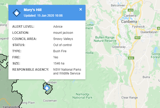
A bushfire burning at Mount Jackson in NSW, called the Mary's Hill fire, is approximately 8 km from the ACT border, and approximately 41 km from the urban interface. The fire is 120 hectares in size. NSW Rural Fire Service has set the alert level of this fire is set at Advice. Follow NSW Rural Fire Service for updates. ACT ESA's Firebird 284 is water-bombing the fire and have activated pre-positioned crews to assist NSW on the fire ground. We will continue to monitor the activity of the fire. There is no bush or grass fires in the ACT.


The Dunns Road Fire is approximately 18km from the ACT border and 48km from the urban interface.
It has been mapped overnight. 620 firefighters and 128 vehicles are working to control the fire. An ACT Task Force, under the direction of NSW RFS is assisting.
While the size of the fire has increased, the rate of spread has been much slower than yesterday's predictions.
The fire still remains within containment lines. The fire is burning south of the Hume Highway in areas around Tumblong, Mount Adrah and Adelong.
The current warning level has been set at Advice.
To view the map in detail visit the ESA incidents map here: https://esa.act.gov.au/
Further information from NSW RFS is available here: https://www.rfs.nsw.gov.au/fire-information/major-fire-updates/mfu?id=8443

This information is current as of 6am, Saturday 11 January 2020.
There are currently 147 fires in NSW, at the time of publication there are no grass or bushfires in the ACT. For the most up to date information on fires in NSW visit the NSW Rural fire Service website.
There is a high chance that the Atkinson and Dunns Road fires may merge today.
This fire is burning 20 km west of the ACT border and 45 km from the urban interface.
It is 114 hectares in size and is burning on all fire edges. The fire is being managed by the NSW Rural Fire Service from the Tumut Fire Control Centre. There are currently no ACT resources allocated to this fire.
Conditions are easing across the fireground.
This fire is now being monitored as part of the Adaminaby Complex Fire.
The main fire front for this fire is 3km south-west of the ACT border and 40km from the urban interface.
The fire is now to 28,640 hectares in size.
Conditions are easing across the fireground.
This fire is being managed by the NSW Rural Fire Service from the Cooma Fire Control Centre. An ACT Strike Team is currently supporting firefighting operations.
This fire is 18 km from the ACT border and 48 km from the urban interface. It is currently
approximately 316,754 hectares in size.
A southerly change has moved across the fireground. Conditions have eased.
There are currently 620 firefighters and 128 vehicles working on this fire.

This information is current as of 6pm, Friday 10 January 2020. For the most up to date information visit the NSW Rural Fire Service website.
There are currently 129 fires in NSW, at the time of publication there are no grass or bushfires in the ACT.
This fire is burning 20 Km west of the ACT border and 45km from urban interface. It is 113 hectares in size, having increased 100% since this time yesterday, and is burning on all fire edges. The fire is being managed by the NSW Rural Fire Service from the Tumut Fire Control Centre.
There are currently no ACT resources allocated to this fire.
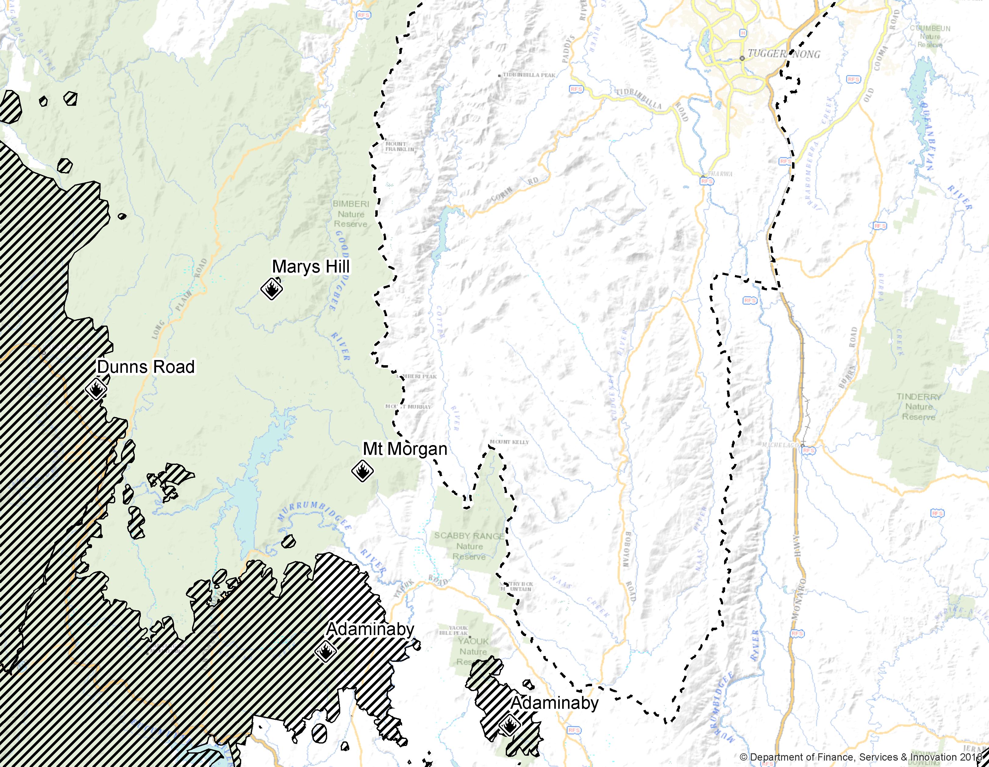
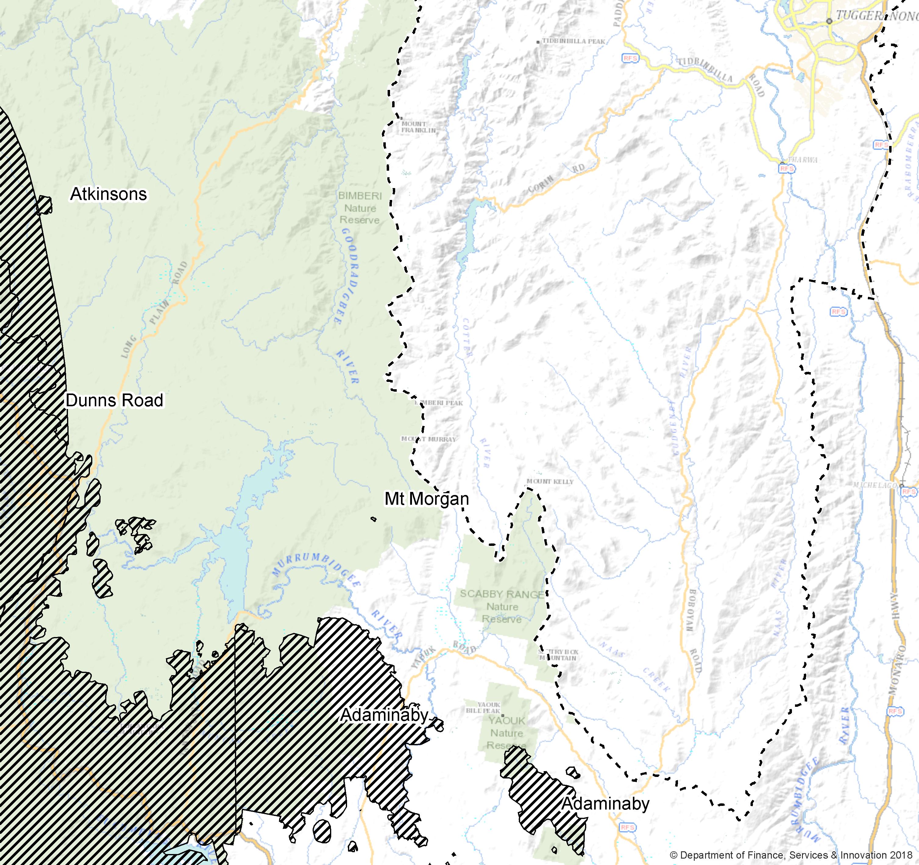
The below image shows the proximity of the Atkinson Fire to the ACT border.
This fire is 4 Km southwest of the ACT border and 37km from urban interface. It is four hectares, the size having been revised downward on updated intelligence was received. There was no active fire spotted at the last patrol in the afternoon of Friday, 10 January. This fire has been managed by the NSW Rural Fire Service from the Cooma Fire Control Centre.
The main firefront for this fire is 8km south-west of the ACT border and 45km from urban interface. There is a small spot fire 3 Km south-west of the ACT border. Activity has increased across the fireground, driven by strong north-westerly winds, bringing the fire to 28,700 hectares in size.
This fire is being managed by the NSW Rural Fire Service from the Cooma Fire Control Centre.
An ACT Strike Team is currently supporting firefighting operations.
This fire is 18km from ACT border and 50km from urban interface. It is currently 305,000 hectares in size. Winds across the fireground are varied, and the majority of the fire activity is on the western and north-western edge. The fire is impacting private pine plantations and there is a possibility the Hume Highway will be closed north of Gundagai. Monitor livetraffic.com for road updates.
There are currently 620 firefighters and 128 vehicles working on this fire.
